Saturday, August 27, 2011

Mt. Dana (Aug 26, 2011)

My last day in Mammoth was reserved for a hike I've been wanting to do for several years now and me staying in Mammoth, it was only 20-30 minute drive away. Mt. Dana is the second highest peak in Yosemite at 13,000 ft. My highest hike to date is just about 11,000 ft (2 of the 3 were this week!), so this would be my first real test of high altitude hiking. I promised myself if I couldn't make it to the top, I would drop out of the Whitney climb in September.

The trail for Mt Dana is an unofficial trail and unmarked, so it was a bit tricky to find. Luckily, I saw two hikers step off of hwy 120 in the vicinity and figured that must be where the trail started. It started in the employee parking area at the Tioga Pass entry station and the trail didn't become obvious until about 100 yards in.

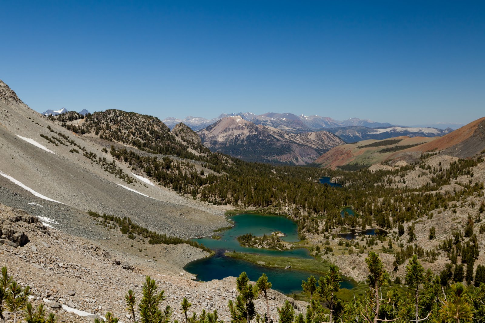
The first half mile is flat and wanders between 3 lakes and serene woods. The meadows and forests in Yosemite are so nice. I promised myself I need to come back and do a nice mellow meadow hike sometime.


This half mile of flat hiking is worrisome. The hike to Mt Dana isn't that long, which makes it attractive. But there's a hidden factor: it has at least 3000 ft of elevation gain. It's supposed to be 3 miles up and 3 miles back, but my gps claims I only did 2.6 miles each way... and if I just hiked a half mile across the meadow, that means the entire 3000 ft of elevation gain is going to happen in about 2 miles. Uh, oh... This is going to be a doozy!

 The climb is in approximately two sections of 1500 ft each with a saddle in between. The first section has a meadowy green section and a rocky second section. This first section had one of the craziest wildflower displays I've ever seen while hiking. They were dense and tall. I passed a few hikers in this area that were only hiking the wildflower section.


Once past the wildflowers, the climb continues, but over rocks. The trail is still marked well, so it wasn't too difficult. Once past this first section I came to the saddle area where the hike flattenss for a bit (which also means the next section really must be steep!) I think the flat saddle area (actually, it still climbs, but feels flat compared to the rest of the hike) was about 11,400 ft or so, if memory serves. After crossing over the top ridge of the first section onto the saddle, I finally got to see the summit of Mt. Dana and what lays ahead. Rocks!


First view of the summit.
The rest of the hike from this point forward was just rocks. The trail eventually disappears and I pretty much had to make my own path to the top. Occasionally you'd come across path like sections from previous hikers, but I'd lose the path and have to rock scramble. About 1/3 of the way up, I really started to hit an altitude wall... around 12,400 ft or so. I was definitely having more difficulty breathing, and scrambling over the rocks really took a lot of effort. The worst came at 12,700 ft and I really started doubting myself. I was having to stop every step or two. I think it took me over an hour to hike the last 500 ft up. The altitude had also swollen my sinuses so I was back to mouth breathing only, making it that much more difficult.

Yes, it's steep and daunting.

You can just barely see the silhouettes of two hikers coming down giving a sense of scale.

One of many patches of snow. Luckily I could go around them.

As hard as the last 500 ft was, and as much as I was nearly ready to quit, I suddenly realized how close to the summit I had come. I had a burst of energy I just went straight to the top without stopping (and videotaped it as well.) Due to the shear elation of making it to the top, I had no problem breathing and felt on top of the world at that moment.


The views from the top were amazing. To the east was a 6000 ft drop to the Mono Basin and all of Mono Lake was in view. In fact, it's probably the best place to take a picture of Mono Lake. I could see the entire White Mountain range past Bishop. Mt Lyell and the Ritter Range were directly to the south and looking awesome covered in snow. To the west I could see all of Tuolumne Meadows. The entire time I was at the top I never once had a breathing problem. I think most of my problems were due to the steepness of the climb at that altitude. Walking around at 13,000 ft caused me no issues. I sat down facing Mono Lake and had a nice 30 minute lunch.

Interactive Panorama on PhotoSynth (make sure to press the full screen icon for the best effect):


Looking east at Mono Lake 6000 ft below and about 15 miles away.

Looking south

Looking west

Looking north

Heading back down was much quicker, but the steepness and treachery of the rocks still limited me to not much more than 1 mile an hour, but since I was going down, I had no breathing issues at all. By the time I got to the bottom I never wanted to see another rock in my life! The hike proved to be quite an amazing journey. A nicely maintained trail would have been welcome, but there was something special about there not being a trail and having to conquer the rocks on their terms. As hard as it was, and I was constantly asking myself can I do another 1,500 ft (Whitney), I did realize that as long as I took my time and controlled my heart rate, I should do fine. Hopefully Whitney has a better trail that doesn't require as much physical effort. My body seemed to deal with the altitude well, but I could certainly use some cardio training to deal with the muscle demands at that altitude.

After the hike I had a well deserved burger and beer in Mammoth and hit the bed early. Saturday morning was time to head home. I considered stopping for a short hike on the way home like Lembert Dome or Tuolumne Meadows, but I didn't sleep well and thought it best to end the trip with a bang at Mt Dana.

Looking back at the summit from the parking area.

All photos are on Smugmug.

GPS track is on Everytrail.

Friday, August 26, 2011

Ancient Bristlecone Forest (Aug 25, 2011)

Today's activities were planned to be a simple day of driving and exploring and giving my feet a break. But, I ended up with a bit of hiking which resulted in breakthrough in preparation for high altitude hiking. Yippee! I hinted in yesterday's post that for the last 4 days of hiking, I've been having a few issues. Basically, whenever I had to go uphill or just pushed myself, I started getting elevated heart rates and felt like passing out! Not good. In fact, I've been silently panicking. I've had a second issue that is commonplace for me as well: at altitude, my sinuses have become congested and I've had difficulty breathing through my nose resulting in poor sleep. I've always had bad sinuses and suffer allergies, so it's something I just live with. But, at these altitudes, losing any amount of breathing ability hurts. Since I had a really bad night's sleep the night before, yesterday I stopped at a dug store and got some nasal spray. I slept like a rock last night. And this morning after using it I really felt great. I ended up doing a 4 mile hike today at 10,000 ft and I really pushed myself. I was doing 3 mph for a majority of the hike and I was able to push through the ascents without any of the previous problems. Letting my nose breathe was critical and I finally feel I can hike the tall mountains... as long as bring some nasal spray along with me. And getting a good night's sleep didn't hurt either.

Now, back to the fun stuff! I was considering that I would explore White Mountain and the Ancient Bristlecone Forests today. I mentioned this to the bartender, who has hiked everywhere around here, and she said I just had to go as it was amazing, so that made up my mind. I didn't think hiking would be involved, so I didn't really bring any hiking gear, but luckily at the last moment I changed out my jeans for a pair of shorts. I drove straight to the Ancient Bristlecone Forest and realized that to see these trees, I had to hike 4 miles at 10,000 ft in a desert. But it actually turned out to be a really enjoyable hike. It was a truly amazing experience to be walking among the oldest living organism on the planet. Many of these trees are 3,000 to 4,000 years old. The oldest living thing on Earth is on this trail and is believed to be 4,600 years old! Simply amazing. Sadly, they won't tell you which tree is the oldest so that it can be protected from damage and I don't blame them. There's just a sign that says it's nearby and you get to guess which one it is. Also amazing were the saplings. I'd see a bristlecone sapling that looked like any ordinary pine that sprouted this spring, but the sign/guidebook noted that the sapling was 50 years old! Wow...


After walking through the bristlecones I still had some time, so I decided to drive as close to the top of White Mountain as I could. As I've been planning a future hike to the Summit, I was aware that road is gated about 7 miles or so from the Summit, so I figured I could at least drive to the trail head and get some nice photos. The rest if the road was gravel and it was difficult driving my sedan much over 12 mph and I was a bit paranoid about cutting a tire on the rocks or banging the suspension too much. As you climb the mountain you get some stunning views of the Sierra Crest. You can nearly see the entire Sierra Crest from south of Mt Whitney all the way to Tahoe. I could also see the mountains ranges surrounding both sides of Death Valley, though the angles were wrong to see the valley floor itself. The distances I could see were stunning. I'm surprised I couldn't see Las Vegas in the distance :)

The Palisades as seen from White Mountain.

Section of the Sierras.

Lunar like surface near the top of White Mountain.

All photos are on Smugmug.

GPS track is on EveryTrail.

Wednesday, August 24, 2011

Little Lakes Valley (Aug 24, 2011)

Today I finally got to properly hike Little Lakes Valley. I've been wanting to hike this for awhile, and earlier this year I tried to (Rock Creek Camping) but there was too much snow.

The hike follows the Rock Creek up the canyon from one lake to the next. It has a gradual ascent that makes it an easy hike with the only steep ascent right at the end at Morgan's Pass, which can be considered optional, to be honest. I did go up and over Morgan's Pass because I just had to know what was on the other side. Rocks, btw. Lots of rocks.

There isn't much to say about this hike that isn't obvious in the photos. The lakes and mountains are gorgeous. The only thing I'd make note of is the path doesn't get very close to Chickenfoot Lake so you need to go off trail to see it, and it is a very nice lake. Worth hunting for. (Actually, there is a sign pointing to it, but the side trail wanders all over the place. I ended up using my GPS's map to make my own way to the lake. Oh, if you go off trail, try and walk on the rocks, not the wild flowers!)

This hike did continue to be a test for me on hiking at altitude. So far I've had no scary problems like headaches, but on this hike and my previous hikes on this trip, I've really gotten short of breath when my heart rate goes up on the steep sections and when I push too far I feel like passing out! I'm learning to really pace myself and stop often whenever I feel the heart rate increase. I'd like to blame it all on living at sea level, but I'm sure it comes down to being out of shape.


All of the photos from this trip are on Smugmug.

The GPS Track is on Everytrail.

End of the World...

Well, not really. But, it sure was interesting. I woke up to the news of the two earthquakes in Colorado  and when I got back to the hotel that afternoon I learned of the 5.6 quake that hit Virginia, of all places. As I was getting ready for bed, everyone back in the SF bay area all started posting on Facebook that they just had a 3.9 quake. I was feeling left out and joked to myself that maybe I'll be next! I guess I'm a good predictor because I got woke up about 5am here in Mammoth from a 4.2 earthquake! Since Mammoth is a very active area, my next "prediction" is that I can see some lava flows before I head home... heh..

Tuesday, August 23, 2011

Exploring Mono Basin (Aug 23, 2011)

Today I played tourist and took my car for spin and explored the area. Just a few miles from my hotel is something called "Earthquake Fault." It's actually a fissure that lava used to seep out of and isn't a fault line. It's quite cool actually and fairly long. It's hard to photograph, but I tried.

Fissure.

Next stop was the Inyo Craters. The drive was on several gravel and dirt forest roads to a small parking lot, then I had to hike 1/2 a mile. The first crater is quite stunning and has greenish water in it. The crater next to it is even larger and blends in with the surroundings. It has a blue lake at the bottom and is so overgrown with trees, it proved impossible to photograph. It's still amazing how young the craters are.

Inyo Crater

I then headed to the June Lake loop. I've been hearing about this for awhile so I was looking forward to it. It was a nice loop around 4 lakes and some amazing mountains. The village near June lake was quite cool and looked like a nice place to stay for awhile.

June Lake.

Silver Lake.

Grant Lake.

Exiting the June Lake Loop, it was just a skip to Mono Lake. Walked through the visitor's center but was disappointed they didn't have a park brochure. I collect brochures from all the national parks I visit. I guess Mono Lake is an odd ball... I don't think it's actually part of the park system, but run by dept. of Agriculture, or something odd like that. I may be completely wrong, though. Later in the day I swung by the south Tufas where you need to pay, and I was able to use my National Park Annual Pass to get in free. So there was some cross-over.


Mono Lake.


After lunch in Lee Vining I drove up a canyon north of Mono Lake. I think the road was 167. Nice paved road for awhile then drove past Lundy Lake. After the lake the road became a gravel road which became rougher and rougher as I went. I really need a 4x4. Some nice mountain views on the drive and saw beaver sign. Back at the lake I spotted a trail going up the mountain and I managed to find the trail head and looked at the map. It looked like a fun trail to do in the future. About 3 miles each way and some good elevation change and alpine lakes.

Some mountains.

Lundy Lake

All photos from the trip are on Smugmug.

GPS Track on EveryTrail:


Monday, August 22, 2011

Devils Postpile (Aug 22, 2011)

I woke up this morning feeling quite good after yesterday's 10 mile hike in the mountains. The only places that bothered me were the places the sun block missed. I always seem to miss a spot. They should invent glow in the dark sun block for dolt-heads like me. Anyways, the feet felt good, but I still wanted a slow hiking day just to let them rest.

With that in mind, I headed to Devils Postpile. (I really want a possessive s on Devils, but I'm just copying the spelling from the park guide.) I figured I could see all the sights and only have to walk 2 miles. Perfect. Hah! Silly me ended up hiking 7 miles. By mile 2 I was feeling every single rock I stepped on yesterday and my toes felt covered in blisters, thought they weren't.

I took the bus from Mammoth to the Devils Postpile bus stop. On the bus ride I planned my hiking order. First order of business was to find Minaret Falls. It wasn't too far or hard to find, yet the trail seemed empty. It didn't get a big photo in the park brochure, so I suppose most visitors didn't know to go find it. I love maps and study every one I can find, so I made sure to find everything in the area to see. The trail leads right up to the base of the falls, though it's not immediately apparent that you can go stand at the base. It took some scary rock hopping, and I did submerge one boot and soaked my sock, but wow, it looked awesome from the base.


Minaret Falls.

After Minaret Falls I headed back down the trail then a short hop to the Devils Postpile. Pretty awesome set of rocks left over from an old lava flow. As the lava cooled, it shrank, and pulled apart. These cracks from pulling apart formed hexagonal basalt columns. Years later glaciers came through the valley and the tops of the columns were polished smooth.

Devils Postpile.

Top of Devils Postpile.

After climbing around Devils Postpile, I hit the trail for Rainbow Falls. Most people wisely took the shuttle bus to shave a few miles, but not me. I hiked all the way, and moaned privately to myself the entire way. My feet had obviously not healed up from yesterday's trek. The clouds were patchy today, so no rainbow for me at Rainbow Falls, but nevertheless, it is quite a nice waterfall. It's close to Vernal and Nevada Falls in Yosemite, in my opinion. The drop isn't as high, but it is wider. That said, the Yosemite falls include the great hike up to them.

Rainbow Falls sans rainbow.

A bit further (half mile?) is the lower Rainbow Falls, but I decided against this as my feet were sore. You can also hike down to the base of the falls. So I headed back to what I hoped was the closest bus stop. If I had fully rested feet, I would also have liked to visit Reds Meadow and Agnew Meadows to take some wildflower photos.

I spent the remains of the afternoon exploring Mammoth Village followed by soaking my feet in the hot tub. Rough life!

All photos are on Smugmug.

The GPS track is on Everytrail.

Sunday, August 21, 2011

Hiking to Duck Lake (Aug 21, 2011)

My plan for day 1 at Mammoth was a nice and easy warm-up hike around the Mammoth Lakes. After looking through my maps and guides, I wasn't excited by most of the hikes, but I did spot one hike that started just past Lake Mary and followed a canyon into the mountains. This was the type of hike I planned this trip around, so I decided to go for it, even though it would be 10 miles round trip and hit 11,000 ft in altitude. A bit more than a warm-up!

Other than a few line drawings in a hiking guide, I had no expectations for this hike. The trail started in a typical alpine forest and there wasn't much visibility through the trees to see what was around me. I was climbing in elevation continuously and I briefly had glimpses of large mountains on either side and those brief views excited me that there might be better payoffs to come.

Early on the trail in the pine forest.

Just over a mile in and I came to Arrowhead Lake. The lack of trees because of the lake let me see the mountain ridges and the views were awesome. I was really beginning to like this hike. Just before reaching the lake I came upon a group of 4 deer. I actually came around a corner was nearly eye to eye. Quite cool. But she took before I get the camera up. I did get a later photo from a distance.

Arrowhead Lake and some nice mountains are beginning to show up.

Another mile or so and yet again another nice lake greeted me. This one was Skelton Lake. It had a cool shape to it and I enjoyed walking a long it for a bit.

Skelton Lake and the mountains are getting more dramatic.

At this point the trees were slowly thinning and after a mile or two I came to Barney Lake. Barney Lake is situated a the end of the canyon so was surround by mountains on 3 sides. The color of the water was amazing. As I passed Barney Lake, I started the climb up the mountain to Duck Pass. As I ascended, I kept get more and more amazing views of Barney Lake, and soon Skelton Lake was visible as well. Mammoth Mountain also came into view and I was getting regular glimpses of the Minarets over near Yosemite.

Barney Lake is in view at the end of the canyon. Duck Pass is just left of center.

Looking back down the canyon at Barney Lake on the way up to Duck Pass.

The hike up to Duck Pass wasn't as hard as it looks and the angle of ascent was no different than the rest of the hike. However, the trail was much rockier and makes the feet hurt more. By the time I got to Duck Pass and was ready to cross over, I was starting to get hungry. Crossing over Duck Pass and you're greeted by the very large Duck Lake and some stunning mountains. The trail follows the lake for nearly a mile to its other end. About halfway down, I decided to kick back and eat lunch while enjoying the views.


Views of Duck Lake.

After lunch I got up to head down to the base of Duck Lake. As I started to put my backpack on I realized the backpack and shirt had become very wet. I was using the backpack as a chair to lean against and I had pushed the water out of my water bladder. I'm always forgetting to close the valve to stop the water from leaking out. Soon after I had walked to the end of the lake and it was time to return.

The hike had gone smoothly and I felt really strong, but I felt worse and worse all the way back to the trail head. I had run low on energy and all the rocks had basically bruised the bottom of my feet. I eventually made it back to my room with extremely sore feet, but after being off them for a few hours they started to come back to life. I really enjoyed this hike and the views were fantastic.

All photos from the hike are on Smugmug.

GPS track is on Everytrail.

Driving to Mammoth (Aug 20, 2011)

Today I'm starting my week vacation in Mammoth Mountain. I drove Hwy 120 across Yosemite and Tioga Pass. I've driven into Yosemite Valley many times, but I've never driven across Yosemite. The drive was beautiful and the scenery beckons you to just hang out and spend a day. But alas, I had to get to Mammoth and check in. I did the drive without stopping, except when I saw the view from Olmstead Point. Cloud's Rest was right there in front of me and I could partially see down to the valley and I was given an entirely new perspective of Half Dome. The Cloud's Rest hike has been on my to-do list for many years and after seeing this view, I must say it's moving to the top of the list. I must do this hike.

As I approached the park exit I could see Mt Dana which I hope to hike by the end of this trip. A steep canyon drops you down to Lee Vining with partial views of Mono Lake. Another 30 miles and I was at Mammoth Mountain Inn and my first restroom break since I left Sonoma! Yes, I drove 5 1/2 hours and drank 3 Gator Ades w/o stopping. After a nice burger and a pinot, I spend the evening in my room going over maps and deciding on tomorrow's hike. I might be crazy, but I think my first hike is going to be a big one! So much for my initial plan of an easy warm-up hike to start the week. Well, this hike has many turn-around points, so it doesn't need to be as long or hard as it could potentially be.

Also, during my drive, I continued to experiment with taking time lapse videos. I took one photo per second for about 4 hours. It's a nice video, but due to the fixed perspective in the car and the speed of the time lapse, much the drive's glory is lost, but it is still a cool video.

At Olmstead Point looking towards Tenaya Lake and Tresidder Peak.

Half Dome as seen from Olmstead Point on Hwy 120.